Welcome to CatMapper
CatMapper organizes dynamic and complex category systems commonly used by social scientists and policymakers, including ethnicities, languages, religions, and political districts. Each of these domains includes thousands of categories encoded in diverse, dynamic and incompatible ways across a growing corpus of thousands of datasets. This creates a bottleneck for social scientists trying to merge diverse datasets to conduct novel analyses. CatMapper aids in overcoming this bottleneck by assisting users in several key activities.
What does CatMapper do?
Objectives. CatMapper assists users in:
Exploring where data is available for complex, evolving categories commonly used in the social sciences (e.g., ethnic, religious, language, geospatial, and archaeological categories). For example, where can I find data on speakers of Yoruba or people who identify as Yoruba or followers of Isese, the Yoruba religion.
Translating categories from new datasets to categories already stored in CatMapper.
Merging data across diverse, external datasets by these complex categories.
Documenting and Sharing their translations and merges so that other users can check and re-use their work.
Apps. CatMapper currently includes two apps aimed at organizing two kinds of categories. SocioMap organizes sociopolitical categories, such as ethnicities, religions, languages, and administrative districts. ArchaMap organizes categories of material objects used in archaeology, including sites, ceramic types, lithic and projectile point types, and faunal types. Our hope in the future is to extend CatMapper’s capabilities to other classes of complex, dynamic categories.
Key concepts in CatMapper
CatMapper stores information on categories (Table 1), how they are related to each other, and how they are encoded by diverse datasets.
Table 1. Examples of CatMapper Category Domains and Subdomains
| App | Primary Domain | Subdomains |
|---|---|---|
| SocioMap | ETHNICITY | |
| SocioMap | LANGUOID | LANGUAGE, DIALECT, FAMILY |
| SocioMap | RELIGION | |
| ArchaMap | CERAMIC | CERAMIC_TYPE, CERAMIC_WARE |
| ArchaMap | PROJECTILE_POINT | PROJECTILE_POINT_CLUSTER, PROJECTILE_POINT_TYPE |
| ArchaMap | PERIOD | |
| All | AREA | ADM0-ADM4, ADME, ADMD, ADMX, PPL, SITE, REGION |
| All | GENERIC |
CatMapper stores contextual information about categories through a range of ties (e.g., contains, district_of, language_of, religion_of) (Table 2).
Table 2. Ties that store contextual information about categories
| Tie | Description |
|---|---|
| X CONTAINS Y | Y is a sub-category of X |
| X DISTRICT_OF Y | X is a geospatial locale for Y |
| X LANGUAGE_OF Y | X is a language associated with Y |
| X RELIGION_OF Y | X is a religion associated with Y |
| X USES Y | Dataset X uses the category Y |
CatMapper catalogues how thousands of external datasets store data on specific categories from the domains (e.g. ethnicity, language, districts, religion, and archaeological categories) described above. For example, Geonames.org, Statoids, GADM, and MARC are four geographical database that store information on thousands of administrative subdivisions worldwide. While they store information about many of the same categories, they usually encode the same categories in very different ways and store different information about them. For example, Table 3 illustrates the different Keys each dataset uses to uniquely encode Greenland, the different names they use and the different parents they assign to Greenland.
Table 3. How different datasets encode information about Greenland
| Dataset | KEY | NAME | PARENT |
|---|---|---|---|
| GADM | GID: GRL | Greenland | |
| GEONAMES | geonameid: 3425505 | Kalaallit Nunaat,Grønland,… | Kingdom of Denmark |
| STATOIDS | HASC: GL | Greenland | |
| MARC | ID: gl | Greenland | North America |
CatMapper uses a network to represent the different claims (e.g., about names, about parents) each dataset makes about Greenland. Specifically, CatMapper represents Greenland and each of the datasets as unique nodes with USE ties emanating from each of the dataset nodes to the Greenland node. Figure 1 illustrates the USES tie from the Geonames dataset node to the Greenland node, with a box including information from the USES tie, including the Key, names, parent, country, and latitude and longitude (in geoCoords) that Geonames specifically assigns to Greenland.
Figure 1. Contents of the USES tie from Geonames to Greenland.
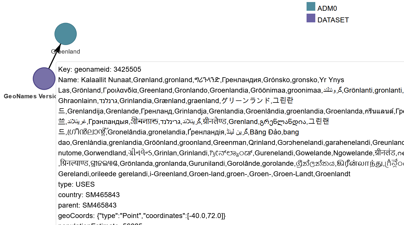
Indeed, whenever CatMapper catalogues how a dataset uses a specific category, it stores this in such a USES tie from the dataset to the category. This USES tie records: (1) how the dataset encodes that category (i.e., name, key), (2) claims that the dataset makes about the category (e.g., geospatial location, population estimate, associated languages and religions, other categories it contains or is contained by). A key specifies how a specific dataset uniquely encodes a specific category. A simple key involves a single variable and value (e.g., V131 = 3). More complex keys can involve combinations of variables and values (e.g., V131 = 3 AND V024 = 1).
Table 4 illustrates key metadata and contextual properties that USES ties can store.
Table 4. Metadata and contextual properties that can be stored in USE ties
| Property | |
| Name | List of names the dataset uses for category |
| Key | Unique identifier dataset uses to encode a specific category. A simple key involves a single variable and value (e.g., V131 = 3). More complex keys can involve combinations of variables and values (e.g., V131 = 3 AND V024 = 1). |
| country | CatMapper id for country or countries that the datasets claims are associated with the category |
| district | CatMapper id for non-country regions that the datasets claims are associated with the category |
| geoCoords | Latitude and longitude that the dataset claims are associated with the category |
| language | Language associated with the category |
| religion | Religion associated with the category |
| recordStart | First year of time span over which the dataset has records for this category |
| recordEnd | Last year of time span over which the dataset has records for this category |
| yearStart | First year the category existed according to the dataset |
| yearEnd | Last year the category existed according to the dataset |
| period | CatMapper id for the time span of the category |
A category set is the set of categories in a specific domain encoded by a specific dataset (e.g., ethnicities coded in DHS Guatemala 1995 survey, language spoken coded in WVS Cote D’Ivoire).